FREEKIN' MUNKEBITES HURRICANE ALERT MODE!!!!!  Can you tell where the hurricane is?
I guess I'd put Munkebites into alert mode since everybody and their brother is.
But this is an historical thing in the making.....Katrina already has become the fourth largest/strongest in the recorded history of Atlantic basin hurricane records. Earlier Sunday, its central pressure dipped to 904 milibars and had sustained winds of 175 mph with gusts of 215 mph. By comparison, Andrew ranks 8th on that list. This is even stronger than Camille in July 1969. If it keeps this current path and strength (some fluctuations are likely), there could be a storm surge in the New Orleans area of about 20-30 feet. That would be devastating.
There is already unprecedented wording coming out of Louisiana local NWS offices. I've never seen them use words such as "devastating" in relation to a storm in my lifetime, while describing the potential for the storm to: "destroy most/all gabled roofs" in the direct damage swath; "cause high rise buildings to sway, with some collapsing possible."
There are even inland tropical storm watches for the southern central Tennessee counties below Nashville. You just don't see that often. The Ohio Valley (central and eastern mainly) could receive 2-5 inches of rain, sustained winds of around 20mph with gusts to 35mph, some sporadic power outages and localized flooding. Expect the Ohio River to rise to perhaps 35 feet in Cincy before this is all said and done. But, that is if the current models are tracking this thing right. They are not all in agreement this far out however.
I think the storm will weaken to a strong Category 4 hurricane before landing just east of New Orleans and the 12:35a.m., August 29th radar returns indicate dry air entraining into the west side of the storm, which will continue the weakening process until landfall. HOWEVER, this is still going to be an historic impact.
Already, there are rumors in Northern Kentucky with the attending runs on gas stations that gas prices are going to shoot to $4.00 per gallon. Although 20% of our useable fuel goes through the Louisiana processing areas, I don't think we'll see that big of a spike. Depending on the total aftermath, expect to see a widespread trickle-down impact across the economic structure of the country. Suffice it to say, I would not want to be building a house in the next few months, if you don't have your lumber ordered yet.
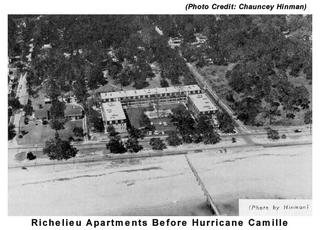
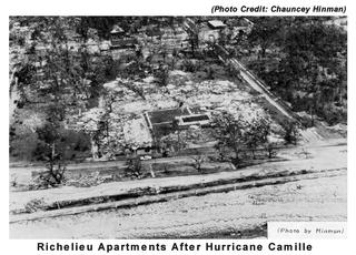
Pray for those who could not get out and pray for the sensibilities of those who, like those who chose to ride out Camille and have a hurricane party in this picture below, might perish because of their foolishness.

Sunday, August 28, 2005
Posted by
glenn
at
8/28/2005 11:51:00 PM
![]()
Subscribe to:
Post Comments (Atom)


0 comments:
Post a Comment