SOME MORE SNOWSLEETFREEZINGRAINRAIN
ALL IN ALL...THIS STORM IS GOING TO CREATE SIGNIFICANT PROBLEMSACRS THE FCST AREA. ANY SHIFT IN TRACK EVEN OVER A SHORT DISTANCEWILL LIKELY IMPACT PCPN TYPE AND DURATION AND RESULTANT SNOW/ICEACCUMS IN ANY ONE LOCATION ACRS FCST AREA. AND AS MENTIONEDABV...DO EXPECT SIGNIFICANT SNOW AND ICE ACCUMS. THIS SURE LOOKSLIKE A STORM THAT WE MAY END UP COMPARING WITH PRE XMAS STORM IN2004 AND THE VALENTINES WEEKEND STORM IN 2003.
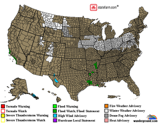
That's the 438 PM EST SUN FEB 11 2007 Forecast Discussion out of the the Wilmington National Weather Service office. Here's the graphical cut of the latest watches/warnings:
Most people really don't appreciate the incredible difficulty in assessing and forecasting a winter storm. There are literally millions of parameters and myriads of scenarios that could happen that affect whether or not someone sees one kind of precipitation. Moisture fetch, air flow patterns, snow-to-liquid ratios, thermal profiles, isentropic lift and many other issues play into the prognostication.
Most people rely upon popular media outlets for their weather information at some point. Often, the information that comes from there is colored by the pressure to secure ratings. Add to that the anomaly of human perception and attention to the details of forecast products.....many of which are embellished by hearsay and pessimistic attitudes that detract from rapidly changing forecasts and conditions. By the time the event is underway, the expectations of some as to what should be occurring might be based on false perceptions and old forecasts. That's a big reason why weather forecasting gets such a bum rap. If you really want to know what's going on, log onto your local NWS forecasting office and read the forecast discussions. These offices are not competing for viewer ratings and are not prone to drama. And they do admit when they make mistakes.
All in all, the comparison to this upcoming storm is to the pre-Xmas 2004 storm and the Valentines Day weekend storm of 2003. That particular wording in a forecast discussion is significant, given the typical, laconic style of forecast discussion texts.
Sunday, February 11, 2007
Posted by
glenn
at
2/11/2007 05:05:00 PM
![]()
Subscribe to:
Post Comments (Atom)


0 comments:
Post a Comment